

The Spatial Concentration and Patterns of Left-Wing Terrorism in Colombia (1977-1997)
Jason M. Belcher
Department of Homeland Security Scholar
University of Maryland - College Park
Abstract
Using data from the GTD, an analysis was conducted on the spatial concentrations and patterns of left-wing terrorism in Colombia from 1977 to 1997. The undergraduate researcher looked for regions of clustering, changes in concentrations, and general spatial patterns of incidents. The Revolutionary Armed Forces of Colombia (FARC), a significant left-wing terrorist group in Colombia, was hypothesized to show unique spatial patterns. The FARC maintains an innovative and flexible strategy which may explain its spatial distribution of attacks. The purpose of this project was to examine general spatial patterns of left-wing terrorism in Colombia with a comparative focus on the FARC. It was found that left-wing terrorism in Colombia is highly concentrated along the Andean mountain range and is predominately a rural phenomenon. In addition, FARC was confirmed to demonstrate a unique spatial distribution of activity.
Significance of Study
- The Republic of Colombia is a country with a long and bloody history.
- Understanding the evolution of Colombian left-wing terrorist groups, their territories, and their capabilities is a vital part of bringing peace to Colombia.
- The ultimate purpose of this project was to describe the spatial elements of left-wing terrorism in Colombia within a historical context in order to guide future policy and research initiatives.
Framing Questions
- What are the spatial dimensions of left-wing terrorism in Colombia?
- Have they changed over time? If so, how?
- Does the FARC demonstrate different geographical patterns than other left-wing groups?
- Have these patterns changed over time? If so, how?
- What does this mean today and are there policy implications?
Materials and methods
- Data from the GTD
- 3,290 incidents by left-wing terrorist groups in Colombia from 1977 to 1997
- Examined 87% of the relevant data (i.e. Colombian incidents with coordinates and group name)
- Used Geographic Information Systems (GIS) software to examine spatial patterns across time
- Variables of interest:
- Spatial patterns over time
- Shifts in urban versus rural locations
Results
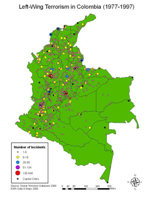
Overall spatial distribution of left-wing terrorism in Colombia. High concentration of incidents along the Andean mountain range, which runs from the Southwest corner to the Northeast corner of the country.
Incident concentration by department. The three most highly attacked departments (Antioquia, Distrito Federal, and Valle del Cauca) contain the country's three largest cities.
Colombian terrorism was initially a predominately rural phenomenon; it then shifted to urban centers during the late 1980s, only to become rural again by 1995.
Terrorism incidents by the National Liberation Army (ELN) were clustered on Colombian oil and gas pipelines.
Patterns of the FARC
The FARC had a unique set of geospatial features that distinguished it from other left-wing terrorist groups:
Wide dispersion and diffusion of activity across country; predominately rural and delocalized.
Conclusions
The results from this analysis have important policy and future research implications:
- Policy makers should continue to focus on hotspot areas where population is dense. However, more rural areas with critical infrastructure (such as pipelines) should not be overlooked. These areas are vulnerable and have been primary targets of both the FARC and the ELN. While the risk of mass casualty is lower in these areas, indirect social damage can still be inflicted through attacks on infrastructure and the proliferation of fear.
- Further research may examine the relationship of political interventions in Colombia with the geospatial patterns of left-wing terrorism. This may help identify specific policy decisions that lead to changes in attack location and frequency.
- In addition, further research may extend the time period of this analysis by observing trends from 1998 to present day, thereby identifying current hotspots in order to more accurately guide policy decisions.
Acknowledgments
Researcher: A Senior at the University of Maryland College Park, Jason Belcher is majoring in Psychology with a minor in Terrorism Studies.
Research Mentors: Dr. Gary LaFree, Brandon Behlendorf
Funding: This research was supported by the United States Department of Homeland Security through the National Consortium for the Study of Terrorism and Responses to Terrorism (START), grant number 2008ST061ST0004. However, any opinions, findings, and conclusions or recommendations in this document are those of the authors and do not necessarily reflect views of the U.S. Department of Homeland Security.
Special Thanks: The author would like to thank DHS for providing the opportunity to intern at START through the DHS Scholars and Fellows Program; my co-researcher Amalia Paladino; Dr. Laura Dugan, Dr. Kathleen Smarick, Dr. Katherine Worboys, and Dr. Richard Legault for their many suggestions and assistance with this project.
Awards
2008 START Annual Conference Best Undergraduate Presentation


